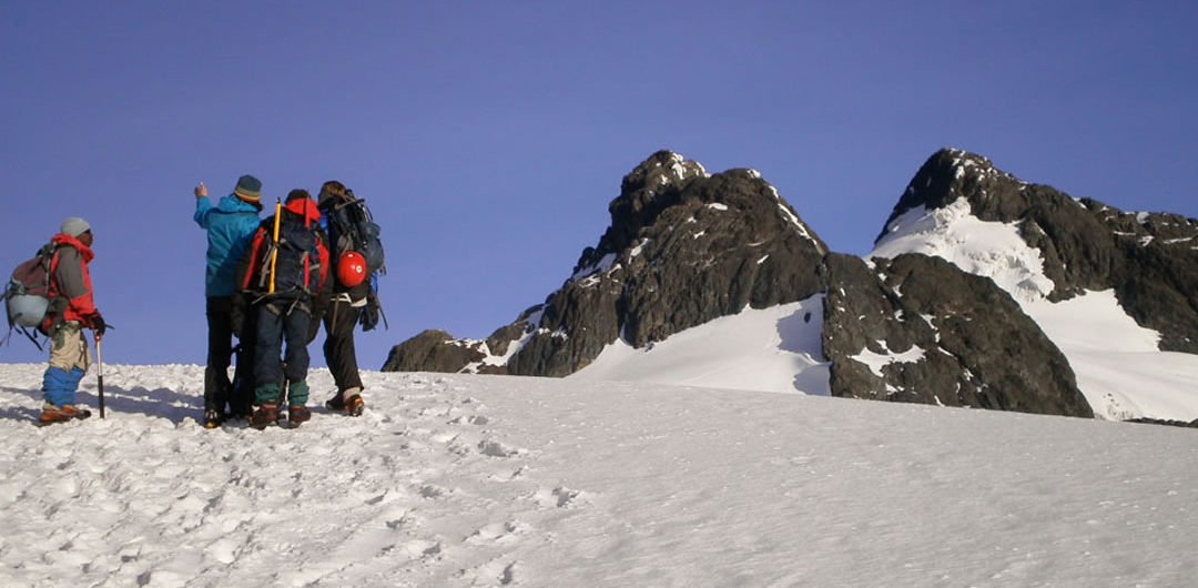
Trekking the Rwenzori mountains is exhilaration and rewarding experience but one, which must be well planned. The key to an enjoyable visit is to be prepared. The conditions and the mountain are challenging to even experienced hikers. Mountain Rwenzori is known for its un-engineered, steep and slippery trails and frequent rain. Rainfall and cold temperatures, bogs, mud, stiff terrain, and high altitude make it a challenging trip. Nevertheless, it’s exciting! You should need to try it! Since during much of the year mud, Rain, Mist, and wind occur daily, adequate clothing (and a mental altitude!) for these conditions are a must. The periods of July-August and December-February are relatively dry and good non and experienced hikers are the best seasons for a trek.
Safari Outline: 10 Days Rwenzori Central Circuit Trail (7 days hiking)
Day 1: Airport Transfer
Day 2: Kampala to Kasese
Day 3: Day 1 of Hiking Mountain Rwenzori
Day 4: Day 2 of Hiking Rwenzori Mountain
Day 5: Day 3 of Mountain Rwenzori Hiking
Day 6: Day 4 of Mount Rwenzori trekking safari
Day 7: Day 5 of Mountain Rwenzori Trekking safari in Uganda
Day 8: Day 6 of Mountain Rwenzori Hiking Safari
Day 9: Day 7 of Mountain Rwenzori Hiking/Descending
Day 10: Day 7 of Mountain Rwenzori /Kasese to Kampala/Airport
Please notes the safari cost include:
- meals and accommodation
- Mountain trekking fees
- Porters and guides
- full-time safari driver/guides,
- park entry, forest guiding walks all activities mentioned in the itinerary while on safari
- applicable Government Taxes.
- 4×4 wheel drive vehicle with gas
- Airport transfers.
- Excluded are:
- Ice ace, crampons ropes( mountain equipment that you will be rented directly from the mountain authorities. estimated each equipment rate range from $12 – 15 dollars for the whole journey, Drinks, your bar bills, phone calls, personal insurance and any other services of personal nature like souvenirs tips and laundry, etc
Day 1: Airport Transfer
You will be met by your driver /guide at Entebbe International Airport who will drive you to Kampala the Capital City of Uganda. Check in at Hotel in Kampala just few minutes outside the city center dinner and overnight.
Day 2: Kampala to Kasese
Drive from Kampala in the morning and proceed to the western part of the country-crossing Equator and arrive in Kasese town ready for lunch. Visit Rwenzori Mountain Services(RMS) in town. After, carryout food shopping together with your guide and help of the Rwenzori RMS staff to stock enough and right food. Dinner and overnight at Magherita Hotel.
Day 3: Day 1 of Hiking Mountain Rwenzori
plan to arrive at Rwenzori mountains national park and the Rwenzori mountaineering services (RMS) offices at Nyakalengija in the morning so as to have apple time to arrange equipments and be availed with guides and porters. Hiking begins from the park headquarters 5400 ft (1646meters), walking past typical ‘mud and wattle Bakonzo homes and gradually moving up ward through elephant grass and garden plots. It takes approximately 40 minutes to reach the park boundary. The trail then follows the Mubuku River, Crossing recent landside areas (to be negotiated carefully), and involves climbing over rocks and bluff before reaching the Mahoma River in about two and a half hours. After crossing the River, there will be a stiff climb through open bracken fern slopes and podorcarpus up to Nyabitaba hut 8700ft (2652 meters). Total time for an average hiker from Nyakalengija to Nyabitaba is about 5-7hours, and total elevation gained is 4000 ft (1200 meters). Slower hikers could take considerably longer, so insist on leaving park headquarters before noon to avoid being on the trail after dark.
Day 4: Day 2 of Hiking Rwenzori Mountain
From Nybitaba hut the trail leads westwards for a half a kilometer, then drops steeply to Kurt Shaffer Bridge crossing below the confluence of the Bujuku and Mubuku Rivers. By turning right to the bridge you will begin to climb a simply circuit anti clock wise since the clockwise direction is much more difficult and adds considerable danger for you and your porters. After crossing the Kurt Shaffer Bridge, the muddy, slippery trail climbs steadily up through bamboo forest. After one and a half hours you encounter an area of slippery boulder hopping which some hikers consider the most difficult and dangerous footing of the circuit.
After 5 hours of travel from Nyabitaba, you reach the hut at Nyamuleju and its accompanying rock shelter. If you had a late start or know that there is a large group ahead of you at the next hut you might consider spending the night here. On a rare clear day Mts. Stanley and Speke can be seen from the top of the rock near the hut. Nyamuleju also marks the start of the giant lobelia and groundsel zone, this remarkable vegetation type is found nowhere else in the world except high-altitude tropical African mountains. The one hour walk to John matte hut (11200ft/ 3414meters) is through a challenging bog, full of extra ordinary plants and the slow pace can be a delightful chance to examine and photograph this unique environment. Typical time to reach John Matte from Nyabitaba is about 7 hours.
Day 5: Day 3 of Mountain Rwenzori Hiking
Leave John matte hut to cross the Bujukiu River and enter the lower Bigo
Bog, where your first real experience of jumping from tussock to tussock on a grassy bog begins. The trail is muddy and flows the left (southern) edge of lower Bigo bog until eventually it reaches the round metal ‘unipot’ the Bigo hut and its rock shelter. A steep section passed the hut leads to upper Bigo bog. In the last half of this bog, a boardwalk has been constructed. Though some may think it’s an ugly intrusion, it makes walking easier and prevents the hiker from damaging the bog. A beautiful narrow stream at the upper end of this bog makes a good lunch break. An hour and a half beyond the upper bog and after climbing through drier ground and criss-crossing the river, you reach lake Bujuku. The southern end of the lake is in a majestic setting, with Mt Baker to the south, Mt Stanley to the west and Mt Speke to the north. The trail route along lake’s north eastern shore crosses the worse mud on the trip. Beyond the north end of the lake is a rock shelter called cooking pot and a short distance further is Bujuku hut 1300ft (3962 meters), favorably located for parties climbing Mt Speke (which requires technical skills and special equipment). Time to reach Bujuku from John matte is typically 3-5hrs, and the elevation gained is 1800ft(560m). But the long stretches of bog, and the mud along the lake makes this challenging day. If one moved around on a nature walk, the chances of seeing Red duikers are high and at night colds of the rock hyraxes are common.
Day 6:Day 4 of Mount Rwenzori trekking safari
from Bujuku hut leave directly to newer trail, which rises and falls twice before finally climbing steeply through magical moss draped groundsel vegetation 14345ft (4372m) to Scot Elliott pass. At the steepest section is a short strong ladder after which a right hand branch will lead to Elena hut 14700ft (4430m). This is a steep, rocky trail which when wet or icy can be slippery. Continuing straight, and a few steps below the pass there a sheltered spot for a break, from here, there a second trail to the right Elena hut. Elena is the best camp for climbing 16763ft (5109m) to Margherita peak in the Mt. Stanley complex, which requires an additional day or two and can only be attempted with an ice axe; mountain boots, crampons, ropes and prior arrangements with RMS guides. The circuit trail continues to the left over Scot Elliott pass and enters an alpine zone of sparse low vegetation and stark rough boulders more familiar to high altitude climbers from northern latitudes. If the weather is bad here (rain, snow and wind can occur in any season) the conditions for ‘hypothermia’ are ideal. Do not delay your descent towards lake Kitandara as you leave the pass, you may enjoy spectacular views northward of Margherita peak, Elena and Savoia glaciers, and Mt Baker 15889ft (4843m) towering above you to the east (left) of the trail. Having dropped a few hundred feet in elevation from the pass, you cut below massive rock walls at the base of Mt Baker. Here, dramatic ‘impact craters’ have been caused by large rocks falling from above, and your guide may caution you against loud noises! Rising and falling, the trail descents passed upper lake Kitandara through thick mud to lower lake and Kitandara hut 13200ft(4023m), this lovely site is surrounded by towering peaks, but the sun sets early and the nights can be very cold. Time to reach Kitandara hut from Bujuku hut usually take 3-5hrs. The elevation gain to the pass from Bujuku is 1400ft (425m), and because Scot Elliott is the highest point so far, some hikers will be slower due to greater effort required at these altitudes watch carefully for signs of altitude sickness.
Day 7: Day 5 of Mountain Rwenzori Trekking safari in Uganda
An early start is advisable to avoid over heating on the steep but lovely hour-long climb from the lake Kitandara, which is 14050ft (4282m) to the fresh field pass. Viewing westward on clear days leads into neighboring Democratic Republic of Congo and northward, Margherita and its glaciers still dominate the horizon. Fresh field is a long flat traverse through beautiful high alpine mossy glades (and more mud) until after a half- hour, when the trail begins the circuit’s long two-day descent. Mist or rain can make tracing the trail difficult and the one-kilometer here can be very slippery. Rock shelters at Bujongolo and Kabamba are optional over-night stopovers but it is best to push on through the seemly endless mud to newly constructed Guy Yeoman hut 10700ft (3261m) some hikers make the Kitandara- Guy Yeoman trip in 5 hours, but any stops to enjoy the pass but weather on descent and slow conditions in the last two hours of deep mud can make this a much longer day, which some visitors consider as difficult as day two.
Day 8: Day 6 of Mountain Rwenzori Hiking Safari
Hikers should begin their journey back early, so as to get to Nyabitaba hut before dark. In any case the path from the Guy Yeoman is quite difficult in some spots. Helping each other and descending very slowly facing the slope instead of facing outward is recommended, especially as you approach Kichunchu where the trail parallels and twice crosses the Mubuku River mostly in deep mud until the last few kilometers of good dry trail. This follows the ridge down Nyabitaba, which completes the circuits. Typical hikers make Guy Yeoman to Nyabitaba in 5 hours. Should you decide to continue to Nyakalengija, which is another 2 or 3 hours depending on the conditions of your knees and your desire to reach a comfortable bed and bath! Be especially careful about vines and brush and resist the urge to hurry out of the mountains. Late even walking can be good for watching birds and you may sight the occasional blue tailed monkeys. Sharp eyes can catch a glimpse of the brilliant green but changeable rhino serous chameleon.
Day 9: Day 7 of Mountain Rwenzori Hiking/Descend to park headquarters. It can take 2- 3 hours
From Nyabitaba to reach Nyakalengija it can take up to three hours. From Nyabitaba starts the 40 minutes trial to see Lake Mamoha and back to the hut for descending to the Park Head Quarter. Picked by your driver to overnight at Hotel Margherita in Kasese town for at least hot showers and good food welcoming you from the mountain.
Day 10: Day 7 of Mountain Rwenzori /Kasese to Kampala/Airport
After Breakfast drive to Kampala with a lunch stop on the way. Stopover on your way could be in Ankole grassland where long-horned cattle are a common sight. Continue southwards stopping at Mpambire in Mpigi an art and craft center where drum making technology has been passed on from generation to generation. Stop at the Equator for photo taking and continue to journey. Proceed to Entebbe airport arriving in time for your flight for your homebound flight. End of Safari.
12 Days Of Wilderness Camping Mount Rwenzori – Bukurungu Trail With Margherita Peak
15 Days: The Uganda Mountain Rwenzori Trekking, Queen Elizabeth and Bwindi Gorilla Tracking Circuit
17 Days: Rwenzori Mountaineering Safari – Margherita Central Circuit Trail (Sleep In Cabins)
20 Days: Rwenzori Mountaineering Safari: Bukurungu Trail ( camping) to Margherita Peak with Uganda wildlife safari
8 Days Mountain Elgon Climbing
Hiking to Mt. Muhavura
Hiking to Mt. Gahinga
Hiking to Mt. Sabyinyo
Comments